India Monsoon Watch: Remnant of South China Sea depression may set up next ‘low’ over Bay


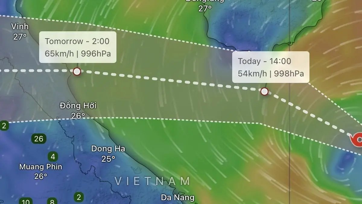
Tropical depression number 20 bracing to enter Vietnam is projected to travel across Thailand and Myanmar and enter the Bay of Bengal to set up a fresh low-pressure area that will continue to drive up rainfall over many parts of India next week.
| Photo Credit:
www.windy.com
An emerging low-pressure area over North-West Bay of Bengal into early August would be inspired by a remnant circulation drifting in from a tropical depression (numbered 20) active in the South China Sea off the Vietnam coast, triggering strong monsoon flows over both the Arabian Sea and the Bay of Bengal and prompting fishermen alerts for next five days.
Low weak, but not rain
This is even as Thursday’s low-pressure area weakened on Friday into a cyclonic circulation over Vidarbha, but not quieting creating an impression on the amount of rainfall being generated over parts of the South Peninsula after it combined with a north-east to south-west-oriented trough from south Chhattisgarh to north Kerala across the circulation over Vidarbha and interior Karnataka. A western disturbance over north Pakistan and adjoining Punjab continued to drive up rainfall over North-West India.
Active monsoon trough
Monsoon easterlies fanned across the backbone trough passing through Bikaner; Kota; Guna; Damoh; Pendra Road; Sambalpur; and Puri before bending into central Bay of Bengal was responsible for rain in North-West India across Uttarakhand; Himachal Pradesh; East Rajasthan; West Madhya Pradesh; Haryana-Chandigarh-Delhi; and Punjab during the 24 hours ending on Friday morning.
Extremely heavy rain
This period also saw extremely heavy rain over Marathwada; Telangana; and Coastal Karnataka; and heavy to very heavy rain at over the hills of West Bengal and Sikkim; East Uttar Pradesh; West Madhya Pradesh; east Gujarat; Marathwada; Telangana; Tamil Nadu, Puducherry and Karaikal; and Kerala and Mahe. It was heavy over Lakshadweep; Arunachal Pradesh; Assam and Meghalaya; Konkan and Goa; Madhya Maharashtra; Vidarbha; North Interior Karnataka; and South Interior Karnataka.
Rain outlook for next week
India Meteorological Department (IMD) has forecast extremely heavy to very heavy to heavy rain over most parts of these regions during the next few days as August, normally second-rainiest monsoon month, gives in to September, the last, as follows:
West India: Extremely heavy rainfall likely over eastern Gujarat and very heavy rainfall over Konkan; Goa; and ghat areas of Madhya Maharashtra and Marathawada on on Friday. Isolated heavy rainfall likely over eastern Gujarat; Konkan and Goa; and Madhya Maharashtra for next seven days; Marathawada for two days; Saurashtra and Kutch on Friday as well as on Thursday next.
North-West India: Isolated heavy rainfall likely to continue over Uttarakhand and East Rajasthan during next seven days; over Jammu and Kashmir; Himachal Pradesh; Punjab; Haryana; and West Uttar Pradesh for five days; over West Rajasthan on Sunday and Monday; East Uttar Pradesh on Friday, Monday and Tuesday. Isolated very heavy rainfall likely over Himachal Pradesh for three days; over Uttarakhand for five days; Punjab on Saturday; and West Uttar Pradesh on Friday and Monday.
South Peninsula: Isolated very heavy rainfall likely over Coastal Karnataka on Friday and Saturday; and Kerala on Friday. Isolated heavy rainfall likely over Coastal Karnataka for next seven days; over Kerala on Friday, Saturday and Wednesday and Thursday next; and over interior Karnataka; Coastal Andhra Pradesh and Yanam; Telangana; Lakshadweep; and Tamil Nadu on Friday.
East and Central India: Isolated very heavy rainfall over hills of West Bengal and Sikkim on Friday; isolated heavy rainfall over Madhya Pradesh during next seven days; hills of West Bengal and Sikkim for three days; Vidarbha on Friday and Thursday next; Bihar on Friday and Saturday; Jharkhand on Saturday and Tuesday next; and Odisha and Chhattisgarh for four days.
East and North-East India: Very heavy rainfall over Arunachal Pradesh; and Nagaland and Mizoram on Friday. Isolated heavy rainfall to continue over Arunachal Pradesh on Friday and Saturday and Thursday next.; and over Assam and Meghalaya; Nagaland; Manipur; Mizoram; and Tripura for seven days.
More Like This
Published on August 29, 2025


