


Fresh ‘low’ over Bay to signal revival of monsoon over Central India
 along the Himalayan foothills, Central India and the West Coast over next four days as a fresh-low-pressure area forms over Bay of Bengal.")
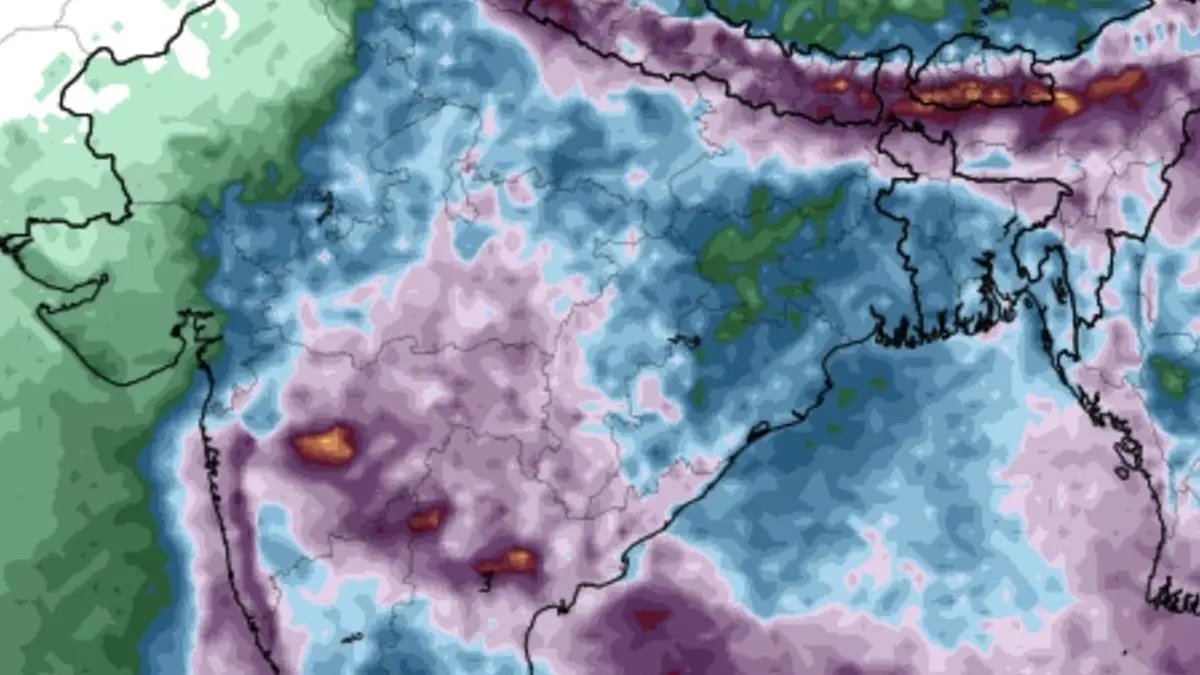
European Center for Medium-Range Weather Forecasts sees heavy to very heavy rain (in purple shade) along the Himalayan foothills, Central India and the West Coast over next four days as a fresh-low-pressure area forms over Bay of Bengal.
| Photo Credit:
www.tropicaltidbits.com
India Meteorological Department (IMD) has confirmed that an upper air cyclonic circulation over the central parts of the Bay of Bengal would descend to lower levels to set up a fresh low-pressure area over west-central and adjoining north-west Bay of Bengal (initially off the Andhra Pradesh coast) by Wednesday, and become ‘more marked’ during two days that follow.
Numerical model predictions indicate it may crawl up along the East Coast towards the Odisha coast during this period, while reviving the monsoon over East-Central India and adjoining North Peninsular India after a recess of more than a week. This would also bring back the monsoon trough to its normal alignment from its current bearing along the Himalayan foothills.
Trough alignment
It is this alignment close to the foothills of North-West and East and North-East India that has been bringing some very heavy to extremely heavy rainfall over Uttarakhand and Himachal Pradesh in the west and Arunachal Pradesh in the east. This had resulted in destructive flash floods and deadly landslides over these areas, leading to loss of lives and damage to property.
‘Low’ to push in rains
On Tuesday, the monsoon trough continued with northern than usual alignment cutting through Bhatinda and Patiala in Punjab and onward close to the foothills of Dehradun in Uttrarakhand before culminating over land in Arunachal Pradesh. Formation of the low-pressure area will bend the trough to south-east so it dips into the waters of the north-west Bay. South-easterly winds from the Bay will carry moisture into East-Central India and North Peninsular India to trigger a fresh rain spell.
Extreme heavy rain
The IMD has forecast extremely heavy rainfall over Uttarakhand in North-West India and over Telangana in the South on both Wednesday and Thursday as the ‘low’ forms. Already, an extremely heavy rainfall alert was valid on Tuesday for hills of West Bengal and Sikkim as well as Assam from close proximity to monsoon trough that nestled in the Himalayan foothills. An incoming western disturbance over north Pakistan and adjoining Jammu and Kashmir on Tuesday boosted the rainfall potential.
Straight westerly track
Numerical model predictions suggest that the ‘low’ may strike up a path straight to the west along Central India (Chhattisgarh, Madhya Pradesh and north Maharashtra) and West India (Gujarat and south Rajasthan) before ending up in the north Arabian Sea where it may reignite by August 20. By this time, a follow-up ‘low’ may spin up over the Bay, setting off another rain spell.
Apart from extreme heavy rainfall prospects, the IMD has issued isolated heavy rain alert for a number of places over North-West India, East and North-East India, East-Central India, Central India, West India, and the South Peninsula over next few days.
Rainfall prospects
North-West India: Isolated heavy rainfall is likely over Jammu-Kashmir for three days from Wednesday; over Himachal Pradesh and Uttarakhand for six days; Haryana, Chandigarh and West Uttar Pradesh for three days; East Uttar Pradesh for two days; East Rajasthan for four days from from Friday. Very heavy rainfall has been forecast over Jammu snd Himachal Pradesh for two days; for five days from Thursday; and over Uttar Pradesh on Wednesday and Thursday. 13th & 14th August.
East and North-East India: Isolated heavy rainfall may continue over Arunachal Pradesh on Wednesday; Assam and Meghalaya for five days; Nagaland, Manipur, Mizoram and Tripura for three days. Isolated very heavy rainfall may continue over the hills of West Bengal and Sikkim and Bihar on Wednesday.
South Peninsula: Isolated heavy rainfall likely over Karnataka for five days from Thursday; over Rayalaseema for two days; Coastal Andhra Pradesh and Yanam and Telangana for six days; Tamil Nadu, Puducherry and Karaikal on Wednesday; Kerala on Wednesday, Sunday and Monday. Isolated very heavy rainfall over Coastal Andhra Pradesh and Yanam on Wednesday and Thursday; Rayalaseema on Wednesday; and over Telangana for four days from Wednesday.
West India: Isolated heavy rainfall is likely over West Madhya Pradesh; Vidarbha and Chhattisgarh for six days; Odisha on Saturday; with isolated very heavy rainfall over West Madhya Pradesh on Monday; and over Vidarbha and Chhattisgarh on Wednesday, Thursday, Sunday and Monday; and over Odisha for three days from Wednesday. Isolated very heavy rainfall is forecast over Konkan and Goa and the ghat areas of Madhya Maharashtra for four days from Friday as the ‘low’ chugs in from Central India.
Published on August 12, 2025
