


Rain-bearing La Nina may emerge for a brief period by December, says Australia’s meteorological organisation
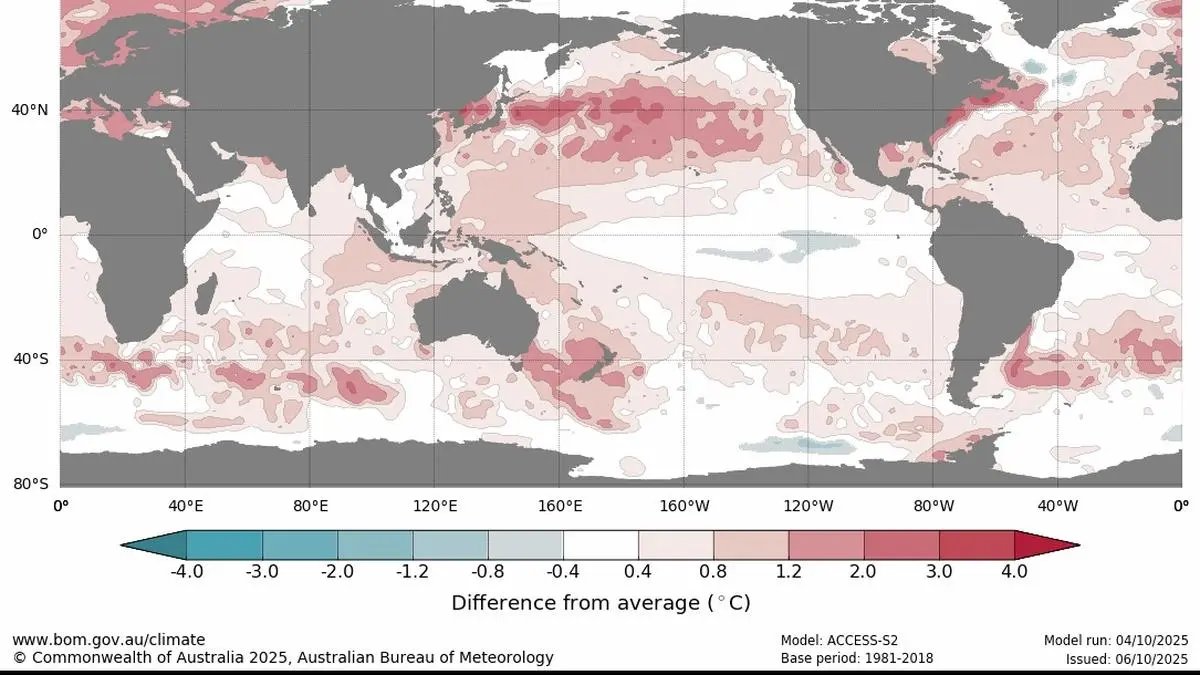

Global sea surface temperature outlooks for the months and season ahead, showing the difference from the long-term mean.
| Photo Credit:
Australian Bureau of Meteorology
La Nina, which results in rain and floods in Asia, particularly India, could emerge for a brief period before the first half of December this year and end by February 2026, the Australian Bureau of Meteorology (BoM) has said.
“The Bureau’s model currently predicts the tropical Pacific is likely to meet La Niña levels briefly during spring (September 23-December 23, 2025), before returning to neutral by summer (December -February). International models indicate some further cooling is likely, also reaching La Niña levels during spring, with all but one returning to neutral by the end of summer,” BoM said in its latest Climate Driver update.
For a La Niña event to be considered established, an atmospheric response would also need to be observed. As of now, the El Niño–Southern Oscillation (ENSO) remains neutral. “The latest relative Niño3.4 SST index value for the week ending September 28, 2025, is −0.80 °C. Values between –0.8 °C and +0.8 °C are considered ENSO-neutral, while sustained values below –0.8 °C (for at least 3 months) are considered indicative of La Niña,” it said.
Sub-surface waters in the central tropical Pacific remain cooler than average, although atmospheric indicators (pressure, wind and cloud patterns) remain mostly neutral. On the other hand, a negative Indian Ocean Dipolie (IOD) is currently underway, with the latest index being −1.24 °C, said BoM.
“Models indicate the negative IOD is likely to persist through December, returning to neutral by December-January,” the Australian weather organisation said.
Global heat
Meanwhile, the Copernicus Climate Change Service (C3S), operated by the European Centre for Medium-Range Weather Forecasts (ECMWF), reports that September 2025 was the third-warmest month on record globally, with an average surface air temperature of 16.11 °C-0.66 °C above the 1991-2020 September average.
According to Samantha Burgess, Strategic Lead for Climate at C3S, global temperatures in September 2025 were the third-highest on record, just under a tenth of a degree cooler than September 2024. She noted that persistently high land and sea surface temperatures continue to reflect the ongoing impact of greenhouse gas accumulation in the atmosphere.
Sea surface temperature
The global average sea surface temperature (SST) in September was 20.72 °C, the third-highest ever recorded for the month, and 0.20 °C below the September 2023 record, the report noted.
Most of the North Pacific continued to record well above-average SSTs, with certain regions reaching record highs.
Around Europe, were much above average to record high across broad area from the Norwegian Sea to the Kara Sea. In the Mediterranean, SSTs were mostly much-above average, particularly in the western and central parts of the basin.
Hydrological highlights
In September 2025, northwestern and central Europe, Fennoscandia, the eastern Black Sea coast, parts of Italy and coastal regions of Croatia, eastern Spain experienced above average rainfall. In some cases, heavy rainfall led to flooding and related disruptions.
Most of the Iberian Peninsula, the Norwegian coast, much of peninsular Italy, the Balkans, and parts of Ukraine and western Russia saw below-average rainfall. Outside Europe, wetter-than-average conditions occurred in the southwestern and central USA, Alaska, northwestern Mexico, and parts of Brazil, Argentina, and Chile.
Rainfall was also above average in the Northern Horn of Africa, southern Arabian Peninsula, Pakistan, northwestern India, central Asia, and eastern China, with heavy precipitation causing flooding in several areas.
It was drier than average in parts of Canada, the eastern US, and northeastern Mexico, as well as in northern and far-eastern Russia, north of India, Uruguay, and parts of Brazil.
Published on October 9, 2025
