


Negative Indian Ocean Dipole likely to persist till December, says Australia’s Bureau of Meteorology
The Indian Ocean Dipole (IOD) is set to stay in a negative phase through the southern hemisphere spring )(September 22-December 21), returning to neutral by early summer, according to Bureau of Meteorology (BoM), Australia report.
The IOD index has been below −0.4°C for seven weeks straight. Prolonged negative IOD conditions usually bring lower post-monsoon rainfall in south and east India, raising concerns for crops and water resources. It could also affect the North-East monsoon, which begins in mid-October and ends in December.
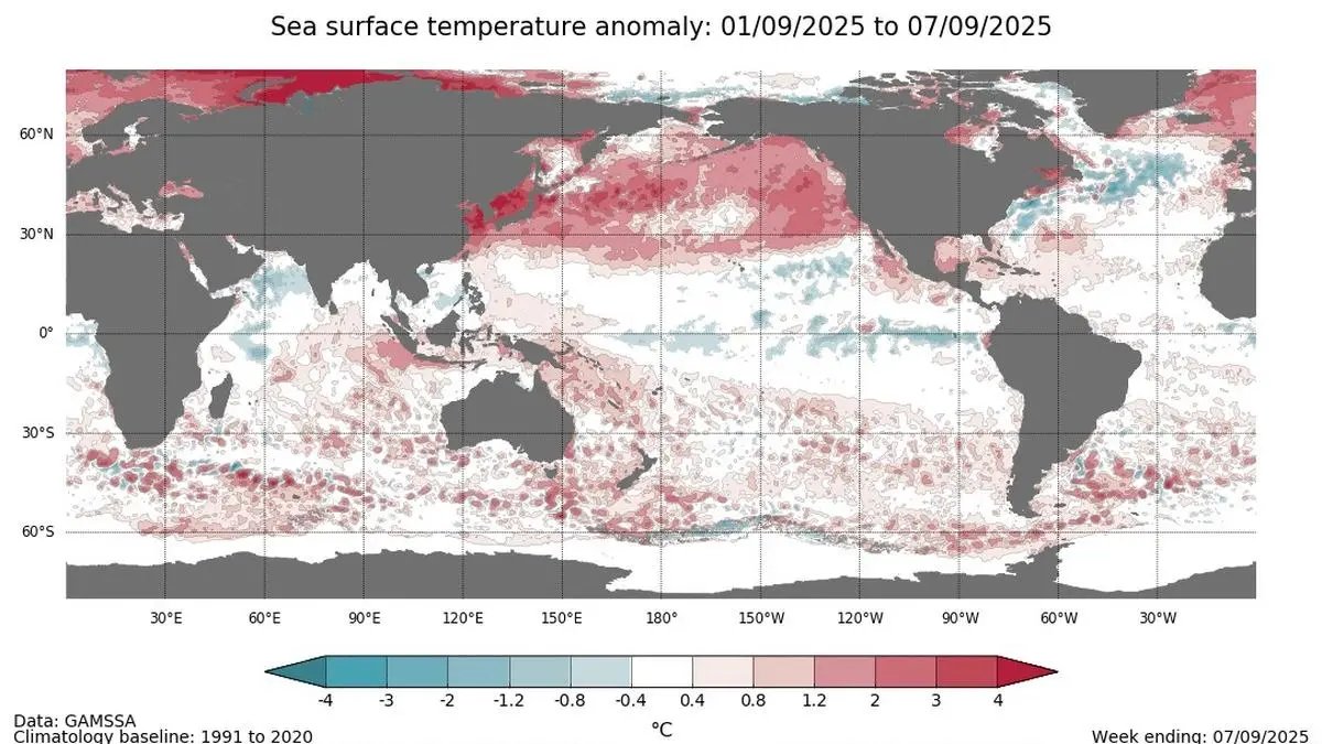
The Bureau said in its Climate Driver Update on Tuesday that the IOD index has met the negative IOD threshold (less than or equal to −0.4 °C) for 7 consecutive weeks. “With a strong forecast for these conditions to continue, it is very likely the threshold will be met for at least 8 consecutive weeks, sufficient to be classified as a negative IOD event. The latest IOD index value for the week ending September 7, 2025 is −1.27 °C,” said BoM.
The El Niño–Southern Oscillation (ENSO) is neutral. The Niño 3.4 index is −0.54°C. The Indian Ocean Dipole (IOD) is negative and expected to continue through spring, it said.
Signs of cooling
The latest relative Niño3.4 value for the week ending September 7, 2025, is −0.54 °C, with weekly values over the past month ranging from −0.5 to −0.6 °C. Neutral ENSO values for relative Niño 3.4 are between –0.8 °C and +0.8 °C. Sub-surface waters in the tropical Pacific have shown signs of cooling in recent weeks, and atmospheric indicators remain mostly neutral.
The model predicts further cooling of the tropical Pacific is likely, potentially reaching La Nina levels briefly during spring and returning to neutral in the austral summer. This is consistent with most international models assessed, with around half indicating ENSO will remain neutral, and the other half indicating La Niña may develop.
August third-warmest ever
Meanwhile, the Copernicus Climate Change Service’s monthly bulletin said August 2025 ranked as the third warmest August ever. The month’s average temperature was 16.60°C, nearly half a degree above what is typical for the month, the Copernicus Climate Change Service’s monthly bulletin stated.
It wasn’t as hot as August in 2023 and 2024, coming in about 0.22°C cooler. But it was still 1.29°C warmer than temperatures before industrial times. The full year from September 2024 to August 2025 was also well above normal, 0.64°C hotter than the recent average and 1.52°C higher than pre-industrial levels.
“In southwest Europe, August saw its third major heatwave this summer, along with severe wildfires,” said Samantha Burgess, Strategic Lead for Climate at European Centre for Medium-Range Weather Forecasts (ECMWF). “The oceans also stayed unusually warm. These conditions highlight how urgent it is to reduce emissions and prepare for more extreme weather events going forward.”
")
Monthly global surface air temperature anomalies (°C)
| Photo Credit: C3S/ECMWF
In Europe, land temperatures were 19.46°C, about 0.30°C above the 1991-2020 average for August.
The largest rise in heat was seen in western Europe, with the Iberian Peninsula and southwest France hit the hardest. Meanwhile, northern parts of Europe, like Fennoscandia and Poland, were cooler than normal.
Beyond Europe, several regions recorded higher temperatures. Siberia, parts of Antarctica, China, West Asia and the Korean Peninsula were warmer than usual. In contrast, Australia was cooler, and other regions, including North America, South America and South Africa, saw mixed weather.
Warm waters
The oceans also showed signs of strain, stated the report. The global sea surface temperature averaged 20.82°C, the third-highest on record. Some areas of the North Pacific set new highs and the North Atlantic near Europe remained unusually warm. The Mediterranean didn’t see as extreme conditions as last year.
Polar melt
Sea ice is shrinking fast. In August, the Arctic had 12 per cent less ice than usual, the eighth-lowest level on record. Antarctica was 7 per cent below average, the third-lowest for the month.
The report also highlighted that the rainfall patterns were uneven. Western and southern Europe, including South Sweden and Northwest Russia were dry. Eastern Spain, Northern Italy and Germany received more than normal rainfall Wetter-than-average conditions were observed mostly over central and southeastern US, parts of Russia, Pakistan, and regions of China and parts of Brazil, Argentina, parts of southern Africa, and southeastern Australia.
Europe’s summer was unusually hot. Temperatures were 0.90°C above the average, making it the fourth-warmest summer in recent years. The northern hemisphere, particularly Asia, recorded some of the largest temperature jumps.
The report also warns that action on emissions and preparing for extreme weather cannot be delayed.
Published on September 9, 2025
