

Monsoon withdrawal process to enter Peninsular India in next 3-4 days
 is forecast to gather pace and enter North Peninsular India (including Maharashtra) in next 3-4 days, according to India Meteorological Department (IMD).")
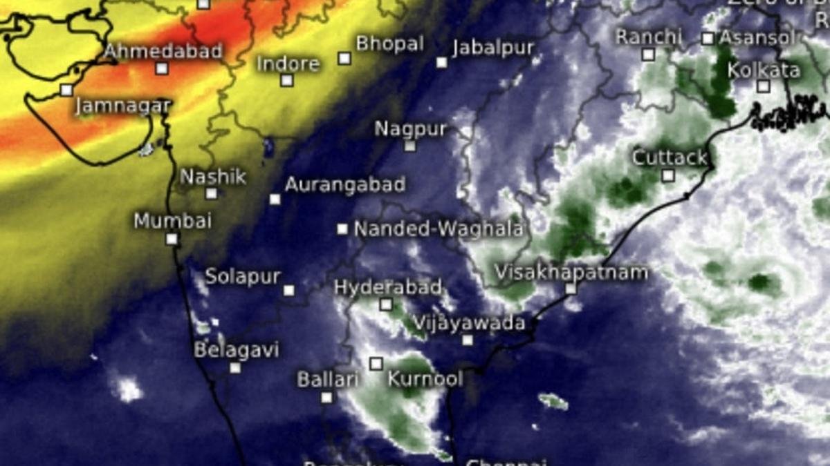
Monsoon withdrawal process (in yellow and gold) is forecast to gather pace and enter North Peninsular India (including Maharashtra) in next 3-4 days, according to India Meteorological Department (IMD).
| Photo Credit:
www.meteologix.com/in
Conditions are favourable for further withdrawal of South-West monsoon from remaining parts of Gujarat; some more parts of Madhya Pradesh; Uttar Pradesh and some parts of Maharashtra during next 3-4 days even as the Bay of Bengal has thrown up signs of transitioning into the monsoon in reverse or North-East monsoon.
Intense disturbance
On Tuesday, an inbound intense western disturbance has transformed into a rare, induced low pressure area over north Rajasthan and adjoining Haryana. The system is feeding on moisture kicked up by the depression from erstwhile severe cyclone Shakhti in the Arabian Sea, and set to unleash heavy rainfall over many parts of hills and plains of North-West India, effectively blocking withdrawal process of the monsoon.
Withdrawal blocked
Vishwas Chitale, Fellow, of Delhi-centred think-tank Council on Energy, Environment and Water (CEEW) said North-West India continues to see significant weather activity due to a strong western disturbance even as the south-west monsoon prepares to exit the region. During the first week of October, Punjab recorded about 415 per cent excess rainfall; Himachal Pradesh 248 per cent; while Haryana, Delhi NCR and Uttarakhand also experienced unusually heavy rain and hailstorms, Chitale told businessline.
On Monday, several States, including Jammu a Kashmir, Himachal Pradesh and Punjab, saw isolated heavy to very heavy rainfall. While rainfall intensity is expected to reduce after today (Tuesday), the India Meteorological Department (IMD) has forecast that overall October rainfall will be above normal — around 115 per cent of long-period average.
Note of concern
A CEEW study finds that more than half of India’s tehsils have seen an increase in October rainfall in the last decade (2011-2022) compared to the 1982-2011 average. This trend, likely linked to the delayed withdrawal of monsoon, is concerning as October coincides with harvesting season for many rain-fed kharif crops, and unseasonal rain during this period can cause significant crop losses, Chitale added.
On Tuesday, a rain-driving trough from a cyclonic circulation located over south-west Bay of Bengal off Tamil Nadu coast ran across Tamil Nadu, Rayalaseema and south interior Karnataka to coastal Karnataka. A second rough ran down from north coastal Odisha to east Telangana across interior Odisha and south Chhattisgarh.
Cyclonic whirls
These two systems are supplemented by cyclonic circulations over north-east Jharkhand, south Bangladesh, and south-west Bay. An upper air cyclonic circulation is likely to form over north Bay of Bengal around Friday by when the prevailing south-west monsoon would have exited from more parts of peninsular India.
The depression from erstwhile severe cyclone over west-central and adjoining north-west Arabian Sea lay centred about 270 km southeast of Masirah; 390 km south-southeast of Ras Al Hadd (both Oman); 970 km east-northeast of Al-Ghaidah (Yemen); 940 km southwest of Karachi (Pakistan); and 950 km west-southwest of Dwarka and 970 km west-southwest of Naliya (Gujarat), the IMD said in an update.
Track of depression
It is likely to continue to move slowly east-south-eastwards (towards India’s West Coast as the system recurves from its track from the high seas) to west-central and adjoining north-west Arabian Sea and weaken into a well-marked low-pressure area. In an an alert to fishermen, the IMD advised them not to venture into along and off Kerala coast and over Lakshadweep area until Thursday; along and off Karnataka coast on Wednesday; and over Gulf of Mannar and adjoining Comorin area from from Friday to Sunday.
Published on October 7, 2025
