

Monsoon to hold sway over North as fresh ‘low’ may form by Monday
 over East and Central India; Konkan and Mumbai; and East Rajasthan until Monday as a fresh low-pressure area forms over Bay of Bengal.")
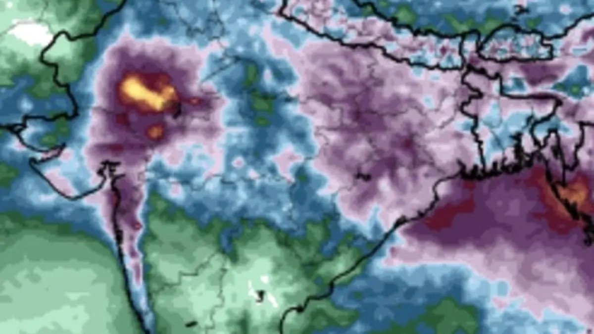
European Centre for Medium-Term Weather Forecasts predicts fresh bout of heavy rain (in purple colour) over East and Central India; Konkan and Mumbai; and East Rajasthan until Monday as a fresh low-pressure area forms over Bay of Bengal.
| Photo Credit:
www.tropicaltidbits.com
The monsoon will continue to hold sway over the northern parts of the country with India Meteorological Department (IMD) confirming on Thursday a fresh low-pressure area is expected to form over north-west Bay of Bengal and north Odisha and West Bengal coasts by Monday. This is even as a circulation from an erstwhile depression hovered over east Rajasthan.
businessline had hinted at the probability of the fresh ‘low’ a week ago in these columns. Numerical weather predictions appear to persist with outlook yet another ‘low’ forming almost around the same area as its predecessor before August ends. A likely north-westerly to westerly track could take both these systems along a track across Central India, North-West and West India.
Parts of Gujarat drenched
The 24 hours ending on Thursday morning saw extremely heavy rain drenching Gujarat while it was heavy to very heavy rain over Assam and Meghalaya; hills of West Bengal and Sikkim; Uttarakhand; Himachal Pradesh; West Madhya Pradesh; East Madhya Pradesh; rest of Gujarat and Saurashtra and Kutch; Konkan and Goa, and Madhya Maharashtra. Heavy rain lashed Arunachal Pradesh; Odisha; Jharkhand; Bihar; East Uttar Pradesh; Haryana-Chandigarh-Delhi; Punjab; East Rajasthan; and Coastal Karnataka.
On Thursday, the core monsoon trough passed mostly along its normal alignment through Jaisalmer; Kota; Datia; Sidhi; Ranchi, Bankur; Digha; and thence southeastwards to east-central Bay of Bengal. The offshore trough lay truncated along Gujarat and Maharashtra, sustaining active monsoon conditions over the West Coast except Coastal Karnataka and Kerala.
Shear zone moves up
This environment continued to be supported by a monsoon shear zone that, however, has moved further northward from around the Mumbai latitude towards north Gujarat, Madhya Pradesh and Chhattisgarh, explaining active monsoon conditions shifting to that region. A western disturbance that hung over the hills of North-West India, providing perfect foil for the monsoon.
In an outlook for West India, the IMD said heavy to very heavy rainfall may continue over north Gujarat for two more days until Saturday even as a fresh spell of heavy to very heavy rainfall may kick off over the state from Monday onwards. Heavy rainfall may also continue over Konkan and Goa as well as Madhya Maharashtra and the ghats region during next seven days.
More rain forecast
As for East and Central India, very heavy rainfall is likely over west Madhya Pradesh and West Bengal on Thursday and Friday; hills of West Bengal on Thursday; Jharkhand and Bihar on Friday and Saturday; Odisha on Friday, Monday and Tuesday; and over Chhattisgarh for three days from Monday, as the fresh ‘low’ forms over north-west Bay, north Odisha and West Bengal coasts.
Over North-West India, isolated very heavy rainfall is likely over East Rajasthan for four days until Monday; Punjab and Haryana on Saturday; Uttarakhand for four days from Friday; Himachal Pradesh for four days from Saturday; and over West Rajasthan on Saturday and Sunday while very heavy rainfall may lash North-East India for two days on Thursday and Friday.
Published on August 21, 2025
