

Low-pressure area forms, waits off Sri Lanka coast
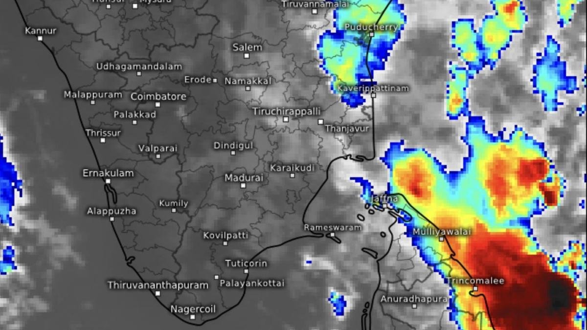

Most of clouds and convection/heavy rain from a low-pressure area persisting over south-west Bay of Bengal on Sunday morning was confined to the eastern seaboard of Sri Lanka.
| Photo Credit:
www.meteologix.com/in
A low-pressure area has formed over the south-west Bay of Bengal off Sri Lanka yesterday (Saturday), but global agencies have discounted the threat of a tropical storm formation over the area to 10-20 per cent. The bulk of rainfall from the ‘low’ was confined to east Sri Lanka coast as revealed by satellite pictures in the morning.
The India Meteorological Department (IMD) said the Sunday morning the ‘low’ persisted over the same area. It is likely to move slowly west-northwest (towards southern Tamil Nadu and adjoining Kerala) until Monday. The IMD is keeping the Bay under watch for signals for formation of a likely second system next week.
Isolated very heavy rains
The IMD has has now predicted with isolated very heavy rainfall over Tamil Nadu for two days (Sunday and Monday), and over south Coastal Andhra Pradesh and Rayalaseema on Monday.
Isolated heavy rainfall is likely over Tamil Nadu, Kerala and Mahe for four days from today (Sunday); over Coastal Andhra Pradesh and Yanam and Rayalaseema on Monday and Tuesday; and for four days over Andaman and Nicobar Islands from Tuesday as the ‘low’ leaves Sri Lankan seas and climbs west-northwest.
Lightning, thunderstorms
An extended range weather forecast from the IMD issued five days ago had projected the ‘low’ may trigger light to moderate scattered/fairly widespread rainfall with isolated heavy falls over extreme parts of south Tamil Nadu and adjoining Kerala during some days of the ongoing week.
Light to moderate rainfall, thunderstorms or lightning are likely at most/many places for four days from Sunday over Tamil Nadu, Kerala and Mahe; Coastal Andhra Pradesh and Yanam and Rayalaseema; and with gusty winds (speed reaching over Andaman and Nicobar Islands, the IMD added.
Storm threat off
Earlier, the Climate Prediction Centre of US National Weather Services had assessed at 20-40 per cent the chance of formation of a tropical storm for the Bay this week with dynamical model support during a climatologically active period for the basin.
The European Centre for Medium-Term Weather Forecasts too had cited possibility for system formation as a remnant from a South China Sea storm entered Bay. Both South China Sea and north-west Pacific to east of the Bay are active even now. The flows are robust and could surprise to spin up a fresh circulation in the Bay.
Published on November 16, 2025
