


Jammu and Kashmir may wake up to heavy rain, snow on New Year day
 has creamed up the hills of Jammu and Kashmir and Ladakh while rain (in blue) is propagating from north Pakistan as a western disturbance announces arrival on eve of New Year.")
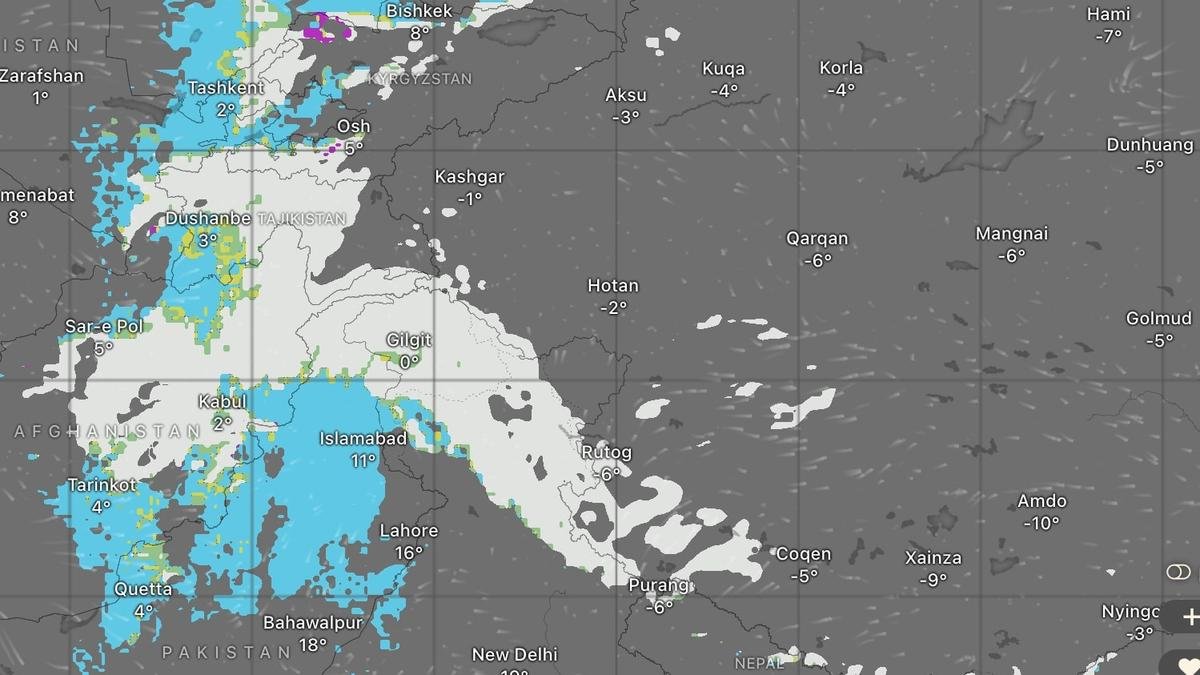
Snow (in white) has creamed up the hills of Jammu and Kashmir and Ladakh while rain (in blue) is propagating from north Pakistan as a western disturbance announces arrival on eve of New Year.
| Photo Credit:
www.windy.com
Jammu-Kashmir-Ladakh region may wake up to fairly widespread to widespread heavy rainfall/snowfall on New Year day, while scattered to fairly widespread light/moderate rainfall/snowfall may linger over Himachal Pradesh and Uttarakhand on Friday as well, India Meteorological Department (IMD) has said.
This would happen as western disturbance with a heat engine chugs in with embedded moisture carry upfront, likely creaming up the hills of Himalayas with snow, and sprinkling/dusting up the plains with rain/showers. Moisture and clouds may help perk up the mercury levels during night but cool it down during day.
Scattered rain for plains
Isolated to scattered to light rainfall is likely over Punjab, Haryana Chandigarh and Rajasthan on Thursday, and over Delhi and west Uttar Pradesh on Thursday. To the south, isolated year-end thunderstorms, lightning and gusty winds may stay put into the New Year over Andaman and Nicobar Islands and Tamil Nadu.
The trough in easterlies over south-east Bay of Bengal has given way to a cyclonic circulation over south-west Bay off Sri Lanka coast on Wednesday. The IMD has predicted isolated to scattered rainfall activity over Tamil Nadu, Kerala, Karnataka and Andaman and Nicobar and Lakshadweep Islands for next three days.
Western disturbance
The IMD has been tracking the the western disturbance from south Iran, which has now moved across Afghanistan and into north Pakistan on Wednesday. It lay parked along a latitude that corresponds to Bathinda, Kurukshetra and Almorah further east across the border into Punjab, Haryana and Uttarakhand in India.
Brief warmth likely
Minimum (night) temperatures over North-West India may rise by 2-4°C during next two days and fall by as much for subsequent three days while no significant respite from the emerging cold is indicated thereafter. Western disturbances leave a trail of frigid air over North-West and Central India after they pass. Gradual rise in night minimum temperatures is likely also over Central India by 2-3°C during next three days.
Night temperatures over Gujarat may fall by 2-3°C on Friday and Saturday and thereafter rise by as much during subsequent five days. No significant change in minimum temperature is expected over Maharashtra for next two days but may fall fall by 2-3°C during subsequent two days before rising as much for next five days.
Dense fog, cold wave
Arrival and passage of the western disturbance may also bring with it dense to very dense fog conditions over North-West India and East India. Being likely thrown in also in the bargain are cold days after clouds associated with the disturbance clear up and allow the cold air to sink to the ground level. Cold wave conditions may creep in even into Telangana on New Year day as cold winds blowing from North-West India.
Published on December 31, 2025
