

IMD Update: Monsoon withdrawal more parts of South India
 settles over Lakshadweep as north-east monsoon prepares to establish likely during weekend.")
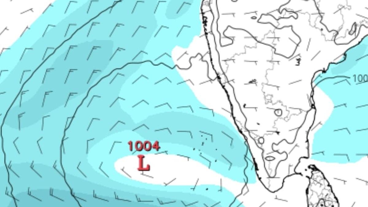
European Centre for Medium-Range Weather supports a scenario where a strong low-pressure area (marked ‘L’) settles over Lakshadweep as north-east monsoon prepares to establish likely during weekend.
| Photo Credit:
www.tropicaltidbits.com
Pace of withdrawal of south-west monsoon appeared to assume a sense of urgency on Monday with the process covering more parts of South Peninsula on Friday, India Meteorological Department (IMD) said. This leaves doors open for monsoon in reverse or north-east monsoon to establish over the region sooner.
On Monday, the June-September monsoon exited parts of Karnataka and some parts of Telangana in South Peninsula as also regions to immediate north and east, including most parts of Maharashtra; entire Goa; remaining parts of Madhya Pradesh; Uttar Pradesh; most parts of Chhattisgarh; remaining parts of Bihar; entire Jharkhand; West Bengal and Sikkim; and some parts of Odisha and the north-eastern States.
Line of withdrawal
The line of withdrawal passed through Karwar; Kalburgi; Nizamabad; Kanker; Keonjhargarh; Sagar Island; and Guwahati. IMD assessed conditions as favourable for further withdrawal from remaining parts Odisha; Chhattisgarh; Telangana; Maharashtra; and the North-Eastern States during next 2-3 days.
Adjoining seas to both sides of the peninsula —the Arabian Sea and the Bay of Bengal —too have been synchronising well with the changing dynamics associated with shift of wind regime from south-west to north-east across land. Facilitating this are upper air cyclonic circulations over Coastal Andhra Pradesh and a twin circulation over nearby south-west Bay of Bengal adjoining south Tamil Nadu.
Ockhi clone seen?
These circulation on the Bay side are being closely watched for signs of further origination and descent to lower levels of the atmosphere for intensification as low-pressure area and onward movement across Sri Lanka and south Tamil Nadu a la cyclone Ockhi eight years ago, along exactly similar track until the Lakshadweep Sea.
But comparisons appear to end here since the current system is seen propelling itself farther away to west from Lakshadweep Islands and out into the south and west Arabian Sea. Cyclone Ockhi had turned north from the islands along India’s West Coast towards Gujarat, leaving a trail of death and destruction. Also an Monday, west-central Arabian Sea hosted a remnant circulation from erstwhile severe cyclone Shakthi.
N-E monsoon prospects
The IMD has predicted isolated heavy rainfall over Tamil Nadu and Kerala and Mahe for seven days during when the north-east monsoon might establish. Similar weather is forecast over South Interior Karnataka; Coastal Andhra Pradesh and Yanam; and Rayalaseema for four days; and over Lakshadweep on Friday and Saturday.
Thunderstorms are expected to roam the larger South Peninsula along with lightning and gusty winds for next 4-5 days. The US Climate Forecast System sees sustained wet weather prevailing over Central India and adjoining Peninsular India for a week and more from October 22 even as parts of the South Peninsula may also slip under an envelope of heavy rain, thunderstorms and lightning to accompaniment of gusty winds.
Published on October 13, 2025
