

Heavy rain alert to parts of Tamil Nadu for next three days


Outlook for next three days shows a rain wave approaching Sri Lanka and south Tamil Nadu, later growing into the interior, especially the ghats areas of the state.
India Meteorological Department (IMD) has forecast isolated heavy rainfall over Tamil Nadu for next three days even as light to moderate rainfall/thunderstorms may fall elsewhere in the state for a day more as prevailing weather over South Peninsula flips in cyclone Montha’s wake.
The IMD extended a similar outlook to Rayalaseema and South Interior Karnataka too for as many days even as lightning and gusty winds (speeds sreaching 30-40 kmph) were forecast for Telangana on Wednesday.
Satellite maps
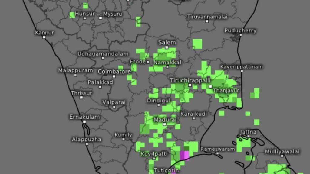
Satellite maps in the evening showed rain-bearing clouds over Cuddalore; Vellore and Chennai (Tamil Nadu); Bengaluru (South Interior Karnataka); Tirupati; Nellore and Ongole (Coastal Andhra Pradesh); Anantapur (Telangana); and along the Western Ghats straddling Kerala and Tamil Nadu.
Causative systems
Wednesday morning’s upper air cyclonic circulation off Coastal Andhra Pradesh has given way to a trough extending from south-west Bay of Bengal to north Kerala across interior Tamil Nadu. To the north, a western disturbance was anchored over north Punjab as a cyclonic circulation, with an offspring ciirculation over north Haryana.
The 24 hours ending Wednesday morning saw significant rainfall (7-11 cm) being recorded at isolated places over North Interior Karnataka in the South Peninsula. Tripura in North-East India benefitted from a weakening low-pressure area off Myanmar-Bangladesh coast and witnessed heavy rain with Sabroom recording 10 cm. In North Interior Karnataka, Yadgir-Gurumithakala-Paspul; Yadgir-Killanakera; Yadgir-Belgundi; and Kalaburagi-Sedam-Motakpalli recorded 7 cm each.
Typhoon Kalmaegi
Global models have been hinting at the possibility of rain-driving easterly waves affecting the Sri Lanka and south Tamil Nadu coasts from today. Prospects could get a likely boost with typhoon Kalmaegi in the west Pacific crossing central Philippines and entering South China Sea, and lobs in a circulation into the Bay.
Kalmaegi is threatening to intensify a couple of notches into a powerful typhoon in the South China Sea, and is expected to make a potentially eventful landfall over Vietnam and Cambodia coasts, putting many lives and property at danger. It has already caused deaths and destruction of property in the Philippines.
More Pacific storms
Global models are also tracking a likely successor to Kalmaegi in the West Pacific, which could become a super typhoon as it moves west-northwest from the West Pacific and enters South China Sea, eyeing the south-west coast of China for a likely landfall. A causative tropical storm numbered W31 (to be named Fung-Wong later) is being tracked on Wednesday, south-southwest of Guam Island, a US territory in West Pacific.
Published on November 5, 2025
