

Fresh ‘low’ forms over Comorin, delays Bay depression by a day
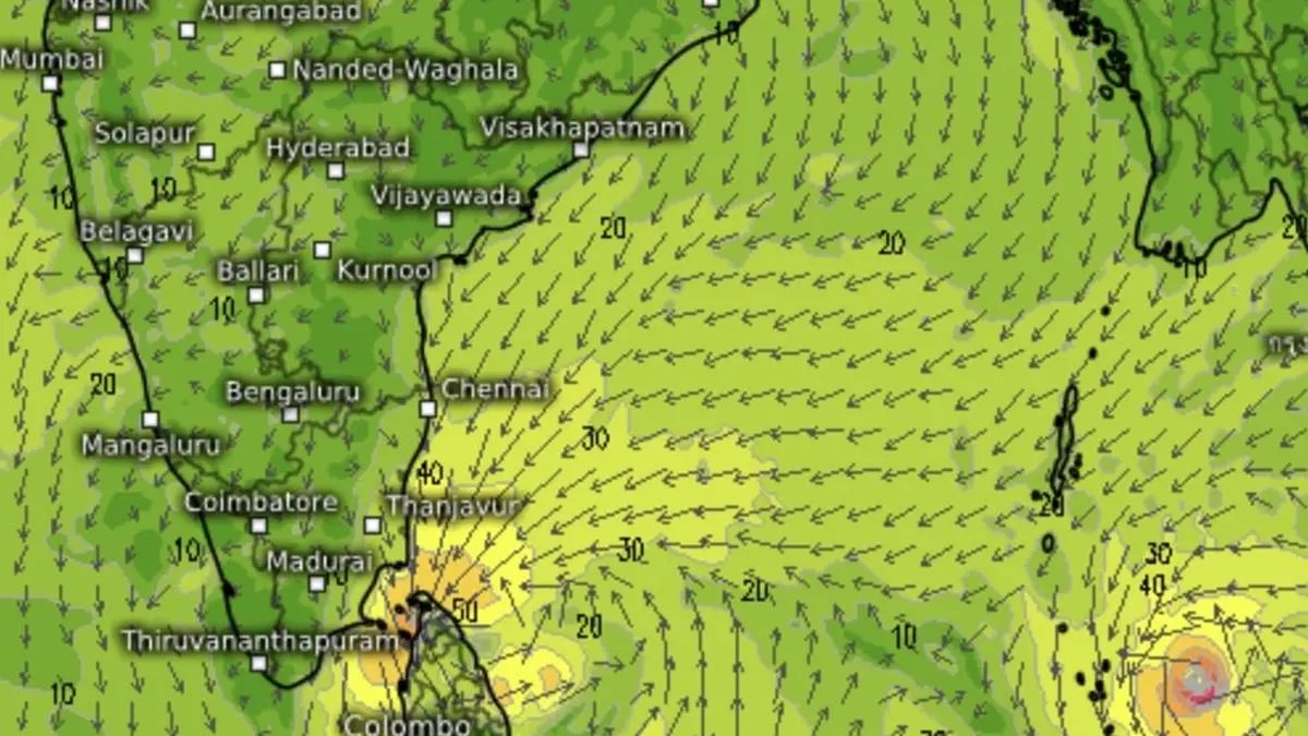

Of 10 global models analysed in terms of forecasts until Saturday, the GFS 0.125 tended to agree with India Meteorological Department’s outlook for two live systems over Lanka and south Andaman Sea.
| Photo Credit:
www.meteologix.com/in
The Bay of Bengal basin, which is expecting to see a cyclone spin up soon, and the Arabian Sea basin to the other side of the South Peninsula, are now proving a meteorologist’s nightmare with no model convergence on outlook until Saturday on level of intensification, track and landfall prospects, if any.
Both seas will turn active with more than one weather system to track, India Meteorological Department (IMD), national forecaster with immediate jurisdiction over territorial waters, suggested based on extended outlook.
Fishermen alert
Fishermen are advised not to venture into story waters of: south-west Bay; Gulf of Mannar; Comorin area; and along and off Tamil Nadu, Puducherry and Sri Lanka coasts for four days until Saturday; adjoining west-central Bay and along and off Andhra Pradesh coast from Thursday to Sunday; south-east Arabian Sea; around Lakshadweep; Maldives and along and off Kerala coast for three days from today (Tuesday).
May head for home
They must keep off south Andaman Sea till Thursday and south-east Bay for three days from today (Tuesday). Those out at sea should avoid south Andaman Sea till Thursday; south-east Bay for until Friday; south-west Bay until Saturday; and west-central Bay from Thursday to Sunday. Fishermen along and off Andhra Pradesh coast have to been directed to return to coast before Friday.
Two live systems
On Tuesday morning, the IMD is tracking two live systems, a well-marked low-pressure area over Strait of Malacca that has already fallen behind original timeline to intensify as a depression (which can happen anytime), as well as a freshly minted ‘low’ over the Comorin and adjoining areas of south-west Bay and Sri Lanka.
Depression soon
The IMD expects well-marked ‘low’ over Strait of Malacca at to move west-northwest and intensify as a depression this morning itself. Continuing to move west-northwest, it is to intensify further into a cyclone (to be named Senyar as per protocol) over south Bay by Thursday, later by a day than originally thought.
Comorin ‘low’
The IMD has now put the ‘low’ over Comorin and adjoining areas of south-west Bay and Sri Lanka under watch for signs of intensification to being ‘well-marked’ by tomorrow (Wednesday). This apart, the IMD expects another system to spin up over south-east Arabian Sea, which appears to confound global model outlook.
Model dissonance
Of the 10 global models analysed with a forecast window extending to Saturday, only one (GFS 0.125) appeared to keep alive two systems till then as the IMD – one around Sri Lanka and the other over the south Andaman Sea. In fact, the IMD has ventured so far as to project the merger of the two, going forward.
The rest of the models keep only one around Sri Lanka as sustaining until Saturday. Some vouched by the potential of the south-east Arabian Sea system, again, just as the IMD does. It may finally wash up over the Kerala-Karnataka coasts
Very heavy rain
Heavy to very rainfall is forecast over Tamil Nadu for three days from Friday; over Andaman and Nicobar Islands for as many days from tomorrow (Wednesday); and over Coastal Andhra Pradesh and Yanam on Sunday, an IMD outlook said. Heavy rainfall is likely over Tamil Nadu for three days; over Kerala and Mahe for two days; over Andaman and Nicobar Islands today and Saturday; and over Coastal Andhra Pradesh and Yanam Saturday.
Thunderstorms and lightning are likely over Tamil Nadu for four days; over Kerala and Mahe for two days; Coastal Andhra Pradesh and Yanam on Thursday and Friday; and over Andaman and Nicobar Islands with gusty wind speeds (40-50 km/hr) during next six days, as they contend with two systems in the neighbourhood.
Published on November 25, 2025
