

Dense to very dense fog warning issued as fresh western disturbance approaches
 as part of the sub-tropical westerly jet stream across North-West India on Sunday. A weather-making western disturbance is hitching a hike on this high-speed wind band.")
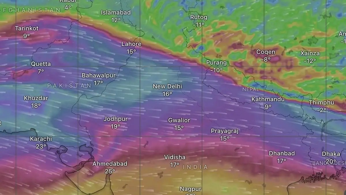
Band of westerlies (in purple) as part of the sub-tropical westerly jet stream across North-West India on Sunday. A weather-making western disturbance is hitching a hike on this high-speed wind band.
| Photo Credit:
www.windy.com
An incoming western disturbance that would modulate winter conditions over North-West India, lay as a trough roughly to north of Kabul and south of Gilgit on Sunday. It is being steered by a sub-tropical westerly jet stream packing strong winds with speeds of up to 278 km/hr at a height of 12 km above sea level.
The jet is a ‘conveyor belt’ in the higher atmosphere pushing low-pressure disturbances eastward. Along the way, they pick up moisture from Black Sea; Caspian Sea; Persian Gulf; and even the Arabian Sea when they are strong and deep enough. The moisture gets lifted up against the Himalayas, releasing rain in plains and snow in hills.
Dense fog
Dense fog conditions are likely during night/morning hours in parts of Himachal Pradesh and Uttarakhand till Friday; over Punjab; Bihar; Uttar Pradesh; Haryana and Chandigarh till Sunday next; over West Rajasthan and Jharkhand till Tuesday; Assam and Meghalaya; North-Eastern States; and hills of West Bengal Wednesday; and Madhya Pradesh and Odisha till Thursday, an India Meteorological Department (IMD) update said.
Cold day conditions aided by calm and clear conditions may break out over Uttarakhand; Punjab; Haryana; Chandigarh; West Madhya Pradesh and Bihar till Monday. Cold wave conditions are likely over Punjab; Haryana; and Chandigarh for four days from Monday; over West Rajasthan for five days; for six days over East Rajasthan; and for two days from Tuesday over Jharkhand.
Clouds, warmth
Moisture associated with a western disturbance also means clouds and warmth, lifting minimum (night) temperatures from extreme cold. The IMD has predicted light to moderate rain/snow over Jammu-Kashmir-Ladakh for three days from Sunday; Himachal Pradesh on Monday and Tuesday; and Uttarakhand on Tuesday.
Leading US meteorologist Ryan Maue sees onset of very cold conditions across much of Europe this week with intrusion of the Arctic ‘polar vortex’. The vortex may cut through London and Paris, with a sharp trough reaching Spain and even the Mediterranean, with likely implications of North-West India.
Ground frost likely
Ahead of arrival of disturbance, prevailing cold may trigger ground frost over Uttarakhand on Monday and Tuesday. Frost occurs when surface temperature drops to or below freezing under clear and calm nights. Frost is a nightmare for standing Rabi crops. Arrival of western disturbance may gradually cause the frost to melt.
The IMD has also forecast dense to very dense fog conditions during night/morning hours over west Uttar Pradesh till Monday; and Madhya Pradesh and Odisha till Tuesday. These conditions may linger at some places over Punjab, Haryana and Chandigarh till Wednesday; and east Uttar Pradesh till Thursday;
Published on January 4, 2026
