

Day temperatures may rise over southern India as stubborn anticyclone bears down over region
High maximum (day temperatures) may prevail over Central India, West Coast and Peninsular India for next 8-10 days with day to day variations, as a stubborn anticyclonic circulation subtly sits in and lords it over southern half of the country.
The anticyclone compresses air, increase pressure, and raise temperature with dry continental winds blowing. To its north, it has cooler westerly-to-north-westerly winds wafting from across Pakistan-Afghanistan border covering North and East India.
Monsoon tracks sun
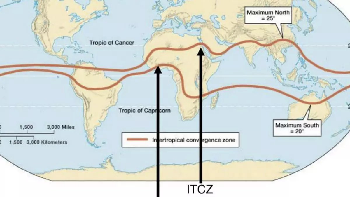
Sun’s position in southern hemisphere has brought monsoon to Australia, after India and South-East Asia. Inter Tropical Convergence Zone (ITCZ), global band of low-pressure tracking the sun, is more or less entrenched over southern hemisphere.
The ITCZ has ascending motion of air, clouds, moisture and therefore the monsoon, and will stay put over the current location until it begins seasonal trek and climbs north to bring back summer and later monsoon to northern hemisphere (Sri Lanka and India) by May/June. Monsoon represents north-westerly flows over Australia and south-westerly over Sri Lanka and India.

Satellite maps on Tuesday morning showed Peninsular and adjoining East-Central India warming up while highest temperatures will be felt along the West Coast and parts of the South Peninsula.
| Photo Credit: www.meteologix.com/in
Stubborn anticyclone
On Tuesday morning, numerical models of India Meteorological Department (IMD) showed anticyclone with cloudless sunny climes and high mercury sitting over from across West Coast (south of Mumbai to Coastal Karnataka); adjoining Maharashtra; Vidarbha; Telangana; Rayalaseema; Coastal Andhra Pradesh; North Interior Karnataka; and North Tamil Nadu (including Chennai).
It may hang over the region until Friday and briefly exit its perch before returning by midweek next week. The interregnum will be marked by entry and exit of cooler western disturbances towards north of the country. Mostly feeble disturbances (and no active ones) entering the region may not bring clouds, associated moisture and rain beyond the hills to standing Rabi crops in plains.
Cooler North India
An IMD outlook on Tuesday morning saw a fall in minimum (night) temperatures by 2-3℃ likely over hills of North-West India from Wednesday from lack of western disturbances. Similarly, no significant change in night temperature is likely over plains during next four days, and over Central India until Wednesday and fall by 2-4℃ subsequent 2-3 days .
Night temperatures may rise by 2-3℃ over East India until Wednesday and fall by 2-3℃ subsequent three days. No significant change is likely over Maharashtra region until Wednesday but night temperatures may fall by 2-4℃ during subsequent four days. Over Centra India, maximum (day) temperatures may rise by 2-3℃ and fall by 3-4℃ for 2-3 days from Thursday.
