


Cyclone roams Arabian Sea as depression leaves East India wet
 poses away from the Gujarat coast on Friday evening as an erstwhile deep depression crossed Odisha coast and lay weakened as a depression (right).")
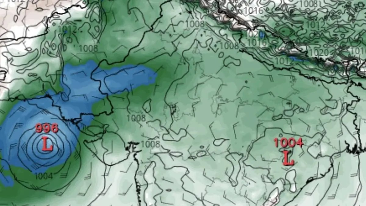
Cyclone Shakthi (in blue and concentric circles) poses away from the Gujarat coast on Friday evening as an erstwhile deep depression crossed Odisha coast and lay weakened as a depression (right).
| Photo Credit:
www.tropicaltidbits.com
Friday’s deep depression over north-east Arabian Sea intensified into a cyclone ‘Shakhti’ that lay centred off the Gujarat coast 250 km west-southwest of Dwarka; 270 km southwest of Naliya; 300 km west of Porbandar; and 360 km south of Karachi in Pakistan. It is likely to move west-southwest out into the high seas and intensify further into a severe cyclonic storm by Saturday.
Depression drenches
It may may head into central parts of north and adjoining central Arabian Sea by Monday, India Meteorological Department (IMD) said in an evening update on Friday. This is even as over mainland India, a depression emerging from the Bay of Bengal is primed to set up varyingly wet weather at many places over next few days.
It was located over interior Odisha and adjoining Chhattisgarh 50 km south-west of Sambalpur (Odisha); 80 km south-southeast of Raigarh (Chhattisgarh); 150 km north-northeast of Bhawanipatna (Odisha); 180 km south-east of Bilaspur; and 220 km south of Ambikapur (both in Chhattisgarh).
System interaction likely
It is likely to move initially north-northwest across interior Odisha and then into north Chhattisgarh and weaken gradually into a well-marked low pressure area by Saturday. It is expected to interact with westerly winds from the opposite side from incoming western disturbances to drive rains.
Cyclonic circulations
An upper air cyclonic circulation lay in wait over north-west Rajasthan while a trough runs from the depression over interior Odisha and adjoining Chhattisgarh to north-west Madhya Pradesh. A western disturbance hung in as a trough over central Pakistan on Friday while a fresh western disturbance may affect North-West India from Saturday night.
Extreme heavy rain
The IMD has forecast isolated extremely heavy rainfall (≥21 cm) over East Uttar Pradesh on Saturday. Isolated to scattered rainfall very likely over North-west India the same day, and increase thereafter with fairly widespread to widespread rainfall accompanied, thunderstorm and lightning for three days from Sunday.
North-West India rain
Very heavy rainfall may lash Jammu-Kashmir; Himachal Pradesh; Uttarakhand; Punjab; Haryana; and Chandigarh-Delhi on Monday. Isolated heavy rainfall is likely over Jammu-Kashmir-Ladakh and Himachal Pradesh for three days from Sunday; Uttarakhand on Monday and Tuesday; Punjab on Sunday and Monday; West Uttar Pradesh; Haryana-Chandigarh-Delhi on Monday and Tuesday; East Uttar Pradesh on Saturday and Sunday; and East Rajasthan on Monday.
Rain for East, South
Towards the east, isolated extremely heavy rainfall (≥21 cm) is likely over the hills of West Bengal and Sikkim and Bihar on Saturday. Isolated very heavy rainfall is likely over the hills of West Bengal and Sikkim and Bihar on Saturday and Sunday. In the south, light to moderate rain or thunderstorms are likely at many or some places with isolated heavy rainfall likely over Tamil Nadu on both these days.
Published on October 3, 2025
