


Cyclone Montha weakens after landfall in Andhra, heavy rain lashes Telangana and Odisha; Arabian Sea depression nears Mumbai coast

Remnant of severe cyclone Montha hovered as a cyclone over Coastal Andhra into Wednesday morning after it made a landfall at midnight along the Andhra Pradesh coast.
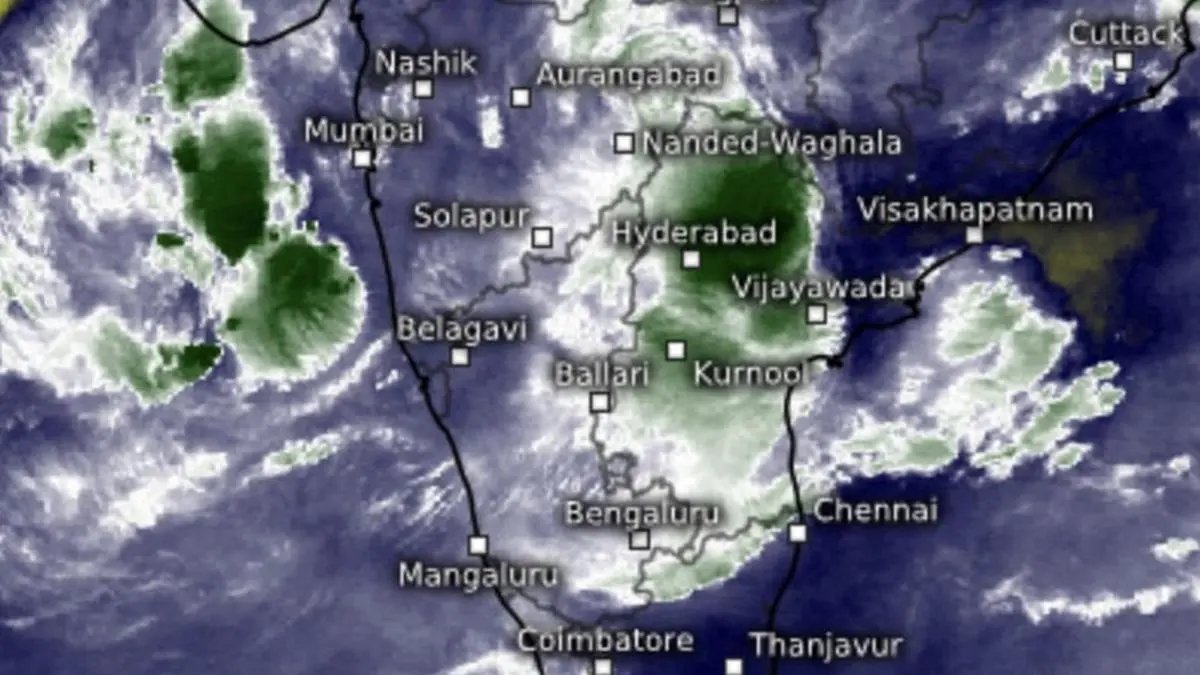
| Photo Credit:
www.meteologix.com/in
Severe cyclone Montha wound down in strength and intensity as a cyclone on impacting land around midnight on Tuesday, but refused to buckle further for three hours after landfall at 2.30 am this (Wednesday) morning.
The India Meteorological Department (IMD) explained that the rear of the cyclone moved entirely over coast by 2.30 am, but it was not expected to weaken as a deep depression at least until 8.30 am this morning.
Cyclone bearing
The cyclone lay centred at 5.30 am about 80 km north-west of Narsapur (Andhra Pradesh); 100 km west of Kakinada; 90 km north of Machilipatnam; 230 km west-southwest of Visakhapatnam (all in Andhra Pradesh); and 460 km south-west of Gopalpur (Odisha) with an attendant heavy rain regime.
Satellite maps at 9.30 am showed a rain belt centred around Warangal in Telangana, extending south-west to Hyderabad; southward to Miryalguda Telangana); south-eastward to Amaravati and Vijayawada (Andhra Pradesh); and farther west and south-westward to Kurnool and Proddatur (Andhra Pradesh).
Arabian Sea depression
The IMD expected remnant Montha to hold on to its status as a cyclone for another three hours (latest status awaited), and move north-northwest across coastal Andhra Pradesh and Telangana before weakening as a deep depression, and further into a depression during subsequent six hours (by afternoon).
Meanwhile, an enduring depression over east-central Arabian Sea moved northeastwards overnight and lay centred about 410 km west-southwest of Mumbai (closest position to coast); 430 km southwest of Veraval; 560 km west-northwest of Panjim; 820 km northwest of Mangaluuru; and 850 km north-northwest of Aminidivi.
The depression is likely to move further north-east (towards Mumbai coast) until Thursday.
Rainfall outlook
The sea-based weather system (depression over Arabian Sea) and two land-based systems – Montha remnant over coastal Andhra Pradesh and a passing western disturbance over North-West and East India – will combine to bring rainfall of varying intensity along South Peninsula and East India in the following manner.
Andhra Pradesh and Yanam: Light to moderate rainfall is very likely at most places with heavy to very heavy rainfallat a few places with extremely heavy rainfall (> 20 cm)at isolated places today over central districts and isolated heavy to very heavy rainfall over remaining districts of Andhra Pradesh. It will reduce tomorrow with isolated heavy rainfallover north Andhra Pradesh.
Odisha:Light to moderate rainfall is very likely at most places with heavy rainfall at isolated places over Odisha today and tomorrow.
Telangana: Light to moderate rainfall is very likely at most places with isolated heavy to extremely heavy rainfall today and isolated heavy rainfall tomorrow.
Chhattisgarh: Light to moderate rainfall is very likely at most places with Isolated heavy rainfall at isolated places today and tomorrow.
West Bengal:Light to moderate rainfall at most places with heavy rainfallat isolated places till 31st October.
Hills of West Bengal and Sikkim:Light to moderate rainfall is very likely at a few places with isolated heavy rainfall tomorrow and heavy to very heavy rainfallon Friday.
Jharkhand:Light to moderate rainfall is very likely at many places with heavy rainfallat isolated places on tomorrow and Friday.
Bihar: Light to moderate rainfall is very likely at many places with heavy rainfalltomorrow and heavy to very heavy rainfallon Friday.
Published on October 29, 2025
