

Cyclone Montha spins up ahead of forecasts, set to intensify
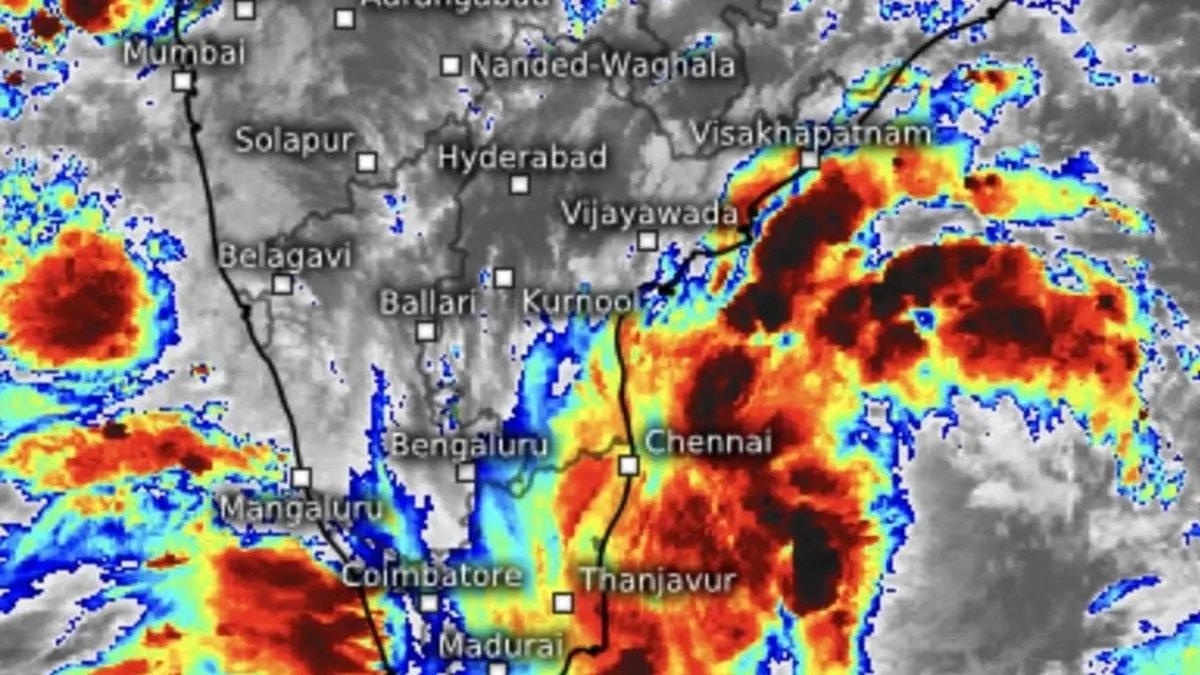

Angry thunderheads ring cyclone Montha that materialsed over south-west and adjoining west-central Bay of Bengal on Monday morning.
| Photo Credit:
www.meteologix.com/in
In a pattern increasingly associated with sea-based storms in the North Indian Ocean in recent times, Sunday’s deep depression over the south-east Bay and adjoining south-west Bay of Bengal beat forecast timelines to intensify as cyclone Montha. It was declared during the intervening midnight of Sunday and Monday, ahead of its expected timeline, as a host of favourable factors hastened intensification off Tamil Nadu-Andhra Pradesh waters.
Landfall tomorrow
Montha is projected to intensify as a severe cyclone featuring wind speeds of 90-100 km/hr, gusting to 110 km/hr and will cross Andhra Pradesh coast between Machilipatnam and Kalingapatnam around Kakinada tomorrow (Tuesday) evening/night as a severe cyclone, the India Meteorological Department (IMD), said.
Extremely heavy rainfall
Extremely heavy rainfall (>20 cm) is warned of over Andhra Pradesh and Yanam tomorrow (Tuesday) and heavy to very heavy rainfall over coastal Andhra Pradesh Wednesday. Heavy to very heavy to extremely heavy rain is also predicted for south Odisha and north Odisha on both Tuesday and Wednesday. Isolated extremely heavy rainfall is forecast for Chhattisgarh, as the cyclone tracks to the east-northeast.
Projected track
The projected away-going east-northeast track for heavy rainfall and stormy weather is pre-ordained by an incoming western disturbance over North-West India. The east-bound disturbance was spotted last (Sunday) night along the Afghanistan-Pakistan border, on its way into Pakistan and onward into North-West India.
Storm coordinates
Montha was located at 4 am on Monday at 600 km east-southeast of Chennai; 680 km south-southeast of Kakinada; 710 km south-southeast of Visakhapatnam; 790 km west of Port Blair; and 850 km south of Gopalpur.
It may move west-northwest during the day on Monday. In a series of projected twists and turns on its path, Montha is initially forecast to move north-west and north-northwest (leaving the Tamil Nadu coast to close in on the Andhra Pradesh coast) and intensify into a severe cyclonic storm by tomorrow (Tuesday) morning.
Likely landfall
Continuing to move further north-northwest, it is forecast to cross the Andhra Pradesh coast between Machilipatnam and Kalingapatnam around Kakinada by Tuesday as a severe cyclone with a maximum sustained wind speed of 90-100 km/hr, gusting to 110 km/hr. IMD appeared to stick to the projected track for the cyclone, to rule out a turn towards the Tamil Nadu coast, as suspected by some models.
High winds
The IMD said gale winds with speeds reaching 60-70 km/hr, gusting to 80 km/hr, prevailed over the south-west and adjoining areas of south-east Bay and west central Bay of Bengal early on Monday morning. Wind speeds may accelerate to 80-90 km/hr, gusting to 100 km/hr over west-central and adjoining north-west Bay from the evening, and further to 90 to 100 km/hr from Tuesday morning.
Squally weather
Squally weather with correspondingly increasing wind speeds are also forecast to develop along and off the coasts of Andhra Pradesh and Yanam; Odisha; West Bengal; and, though with lower intensity, along and off the Tamil Nadu and Puducherry coasts for next two or three days.
Meanwhile, the stubborn depression that appeared to live beyond its life over east-central Arabian Sea, hung gamely to its overnight, bearing at 790 km west of Panjim; 810 km west-southwest of Mumbai; 810 km west-northwest of Aminidivi; and about 940 km west-northwest of Mangaluru. The IMD expects the system to recurve towards east-central Arabian Sea (facing towards West Coast) through the day today.
Published on October 27, 2025
