

Bay of Bengal may come back to life next week
 starting to build along South Tamil Nadu coast until Kaveripattinam to north ahead of a stronger wain wave (in pink) approaches the coast.")
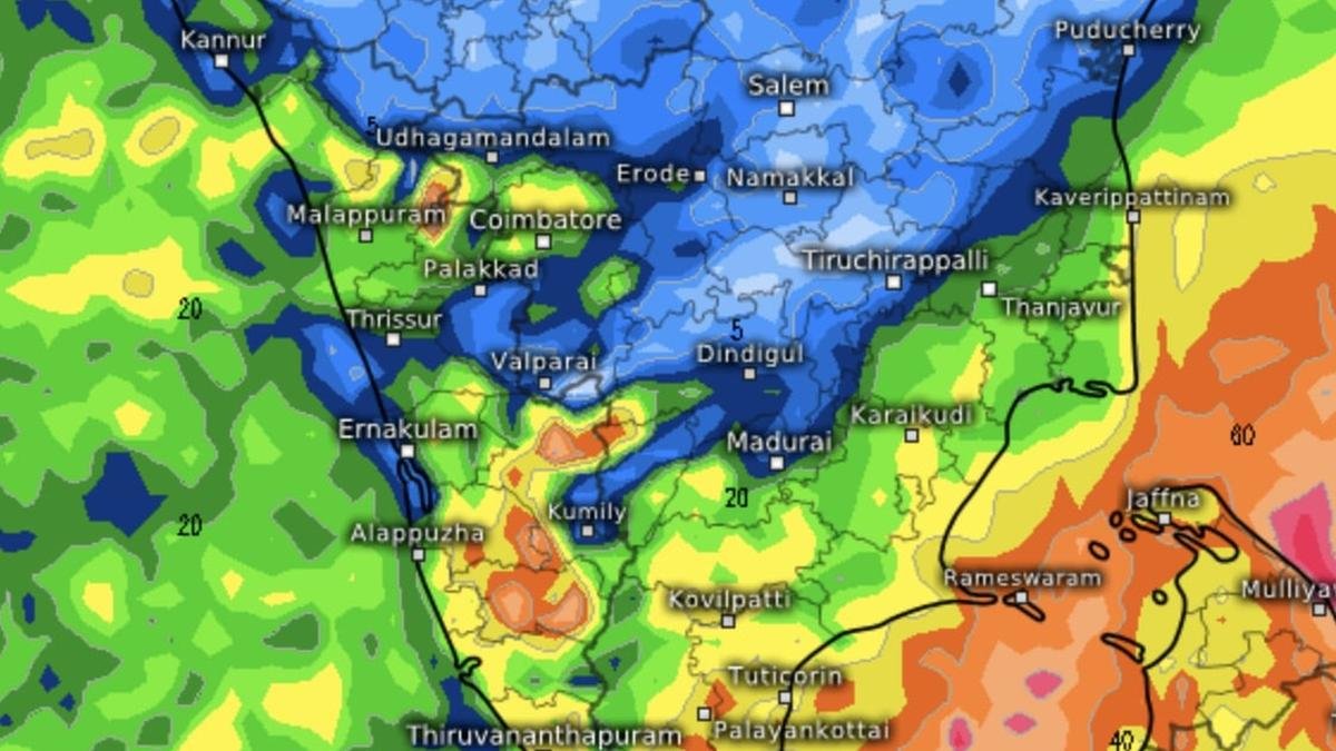
Forecasts valid until Monday show rain activity (in yellow and green) starting to build along South Tamil Nadu coast until Kaveripattinam to north ahead of a stronger wain wave (in pink) approaches the coast.
| Photo Credit:
www.meteologix.com/in
Fairly widespread to widespread rainfall is likely over Tamil Nadu, Kerala, the Andaman and Nicobar and Lakshadweep islands, an update from India Meteorological Department (IMD) said on Thursday morning.
Isolated to scattered rain is likely over Coastal Andhra Pradesh, Coastal Karnataka and South Interior Karnataka during this period. Satellite maps showed rain-bearing north-easterlies to easterlies blowing into a circulation to the south-east of Sri Lanka embedded in a trough, impacting Tamil Nadu and Sri Lanka coasts.
Brewing storm
This circulation may persist and gain traction over the next few days to tick off activity in the Bay of Bengal that otherwise resembles a ghost town after cyclone Montha sped away to the north and east mainlands.
The Climate Prediction Centre of of the US National Weather Service has assessed that there is a 20-40 per cent chance of a major storm system developing off the Tamil Nadu and Sri Lanka coast during the week, beginning November 19 (Wednesday next) during what is considered a climatologically active period for the Bay basin.
Hints of next storm
This will likely be triggered by a storm upstream over South China Sea/north-west Pacific. In fact, the US agency sees these sea basins lying just to the east of the Bay remaining active during this period and beyond.
A cyclone genesis tracker from the European Centre for Medium-Range Weather Forecasts has also hinted at the formation of a storm in the Bay as a remnant system from the South China Sea drifts in. It shows the system posing off the Tamil Nadu coast during the week, beginning November 24 (Monday next).
Typhoon Fung Wong
On Thursday morning, typhoon Fung Wong, which had hit the Philippines as a category-4 cyclone, had entered the South China Sea but turned north-northeast to hit the southern tip of Taiwan to emerge back into the north-west Pacific where it had taken birth as a low-pressure area and rapidly gained strength.
Strong north-easterly flows in the rear of typhoon would set up the precursor ‘low’ over South China Sea during the next two-three days. This is forecast to move to the west, and cross the Gulf of Thailand, and into the Bay.
Closer home, the Myanmar Department of Meteorology and Hydrology has said in 10-day outlook said that a low-pressure area may form over the Andaman Sea and the Bay in the territorial waters, a hop-in away from South China Sea. This would likely be the precursor to the storm system developing in the Bay later.
IMD charts agree
India Meteorological Department (IMD) has hinted in its numerical weather model prediction charts at formation of the ‘low’ over Andaman Sea by Monday (November 17) crossing in from the Gulf of Thailand (part of South China Sea), and later gathering strength as a possible cyclone off Tamil Nadu coast.
Published on November 13, 2025
