


Montha intensifies as a severe cyclone, landfall by evening
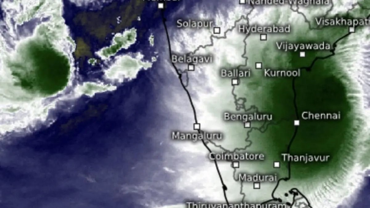

Satellite pictures on Tuesday morning showed cloud cover from severe cyclone Montha extending from south Tamil Nadu coast till Visakhapatnam on Andhra Pradesh coast and adjoining interior.
| Photo Credit:
www.meteologix.com/in
Cyclone Montha over west-central Bay of Bengal intensified into a severe cyclone and lay centred this (Tuesday) morning 190 km south-southeast of Machilipatnam; 270 km south-southeast of Kakinada; 340 km south-southwest of Visakhapatnam; and 550 km south-southwest of Gopalpur.
Extremely heavy rain fell during the day yesterday (Monday) till 5.30 pm over Coastal Andhra Pradesh. It was heavy rain over East Rajasthan (from the Arabian Sea depression), and at isolated places over Tamil Nadu; east Gujarat; and Saurashtra and Kutch. Thunder squalls wind speeds of 60-70 km/hr have been warned over Chhattisgarh today; and wind speeds of 50-60 km/hr tomorrow.
Landfall timeline
The India Meteorological Department (IMD) said the severe cyclone may move north-northwest sand cross Andhra Pradesh coast between Machilipatnam and Kalingapatnam around Kakinada during evening/night as a severe cyclone with a maximum sustained wind speed of 90-100 km/hr gusting to 110 km/hr. It was erroneously mentioned in these columns the landfall had been advanced to midmorning.
Extremely heavy rain
Extremely heavy rainfall (≥21 cm) is likely at Coastal Andhra Pradesh and Yanam today and tomorrow (Tuesday and Wednesday). Isolated heavy rainfall is likely over Coastal Karnataka; north interior Karnataka; Tamil Nadu; Kerala and Mahe today. Isolated very heavy rainfall is likely over Tamil Nadu and Rayalaseema today; over Telangana both today and tomorrow; and Coastal Andhra Pradesh and Yanam, on Thursday.
Going further east-northeast, the IMD said very heavy rainfall is likely over Vidarbha and Chhattisgarh tomorrow; hills of West Bengal and Sikkim on Friday; Bihar on Thursday and Friday; and over Jharkhand on Thursday.
Arabian Sea depression
The depression over east-central Arabian Sea moved north-east (facing the West Coast) and was located this morning 510 km south-southwest of Veraval; 580 km west-southwest of Mumbai; 660 km west-northwest of Panjim; 840 km north-west of Aminidivi; and 890 km west-northwest of Mangaluru. It may move nearly north-northeastwards across east-central Arabian Sea until tomorrow morning.
Rain-bearing trough
A rain-bearing trough extended from the depression over east-central Arabian sea to west Madhya Pradesh across north-east Arabian sea and south Gujarat. At the same time, western disturbance as a trough had drifted into the north-west Rajasthan.
The two will combine to bring isolated very heavy rainfall over east Gujarat on Friday, and over Saurashtra and Kutch for three days from tomorrow. Isolated heavy rainfall is forecast over south Konkan and Goa and Madhya Maharashtra today and tomorrow; over Gujarat for three days from today.
Published on October 28, 2025
